Fire Control Tower List: Difference between revisions
J. Malcolm (talk | contribs) mNo edit summary |
J. Malcolm (talk | contribs) mNo edit summary |
||
| Line 83: | Line 83: | ||
|Radar located on the roof for Battery Carpenter and backup for Battery Ferguson. | |Radar located on the roof for Battery Carpenter and backup for Battery Ferguson. | ||
Operations and generator building converted to homes. | Operations and generator building converted to homes. | ||
|Private Property | |Private Property | ||
|- | |- | ||
| Line 145: | Line 137: | ||
|All Stations private property or sealed | |All Stations private property or sealed | ||
|- | |- | ||
| | |[[File:Levett (79) 48.jpg|thumb|99x99px|Site 1B]][[File:Levett (79) 15.jpg|thumb|99x99px|Site 1E]][[File:Levett (79) 08.jpg|thumb|100x100px|Site 1F]][[File:Fort Levett22.jpg|thumb|151x151px|Site 1H]][[File:Fort Levett17.jpg|thumb|102x102px|Site 1J]] | ||
File:Fort | |||
|[[Fort Levett|Cushings Island ME]] | |[[Fort Levett|Cushings Island ME]] | ||
|<u>Site 1B:</u> | |<u>Site 1B:</u> | ||
| Line 212: | Line 202: | ||
|Cushings Island is private | |Cushings Island is private | ||
|- | |- | ||
| | |[[File:Trundy Point MR 34.jpg|thumb|164x164px|Site 1A]][[File:Trundy Point MR 01.jpg|thumb|164x164px|Site 1B]] | ||
File:Trundy Point MR 34.jpg| | |||
File:Trundy Point MR 01.jpg| | |||
|[[Trundy Point MR|Trundy Point ME]] | |[[Trundy Point MR|Trundy Point ME]] | ||
|<u>Site 1A</u> | |<u>Site 1A</u> | ||
| Line 240: | Line 227: | ||
|Both towers open to public | |Both towers open to public | ||
|- | |- | ||
| | |[[File:Cape Elizabeth MR 15.jpg|thumb|165x165px|Site 1B]][[File:Cape Elizabeth MR (2) 30.jpg|thumb|166x166px|Site 2A]] | ||
|[[Cape Elizabeth MR|Cape Elizabeth ME]] | |[[Cape Elizabeth MR|Cape Elizabeth ME]] | ||
| | |<u>Site 1B</u> | ||
| | * [[Cape Elizabeth MR|Battery 201]]-Upper | ||
| | * Unused-Middle | ||
| | * [[Cape Elizabeth MR|Battery 201]] BC-Lower | ||
<u>Site 2A</u> | |||
* [[Peaks Island MR|Battery 203]]-Upper | |||
* [[Jewell Island MR|Battery 202]]-Lower | |||
|<u>Site 1B</u> | |||
Cylindrical tower to simulate silo | |||
<u>Site 2A</u> | |||
Built atop old lighthouse to simulate water tower | |||
|<u>Site 1B</u> | |||
1943 | |||
<u>Site 2A</u> | |||
1874-1942 | |||
|<u>Site 1B</u> | |||
* Nearly identical to the station at [[Emerson Point MR]] | |||
* Wooden ladders rotted | |||
<u>Site 2A</u> | |||
* Built atop the Cape Elizabeth West Light | |||
* SCR 296 for Battery 201 on roof | |||
* Earlier 1925 station for Battery Kearny-Chase | |||
|Both closed to the public at this time. | |||
|- | |- | ||
| | | | ||
| | |[[Prouts Neck MR|Prouts Neck ME]] | ||
| | | | ||
| | | | ||
| Line 255: | Line 263: | ||
|- | |- | ||
| | | | ||
| | |[[Fletchers Neck MR|Biddeford Pool ME]] | ||
| | | | ||
| | | | ||
| Line 262: | Line 270: | ||
|- | |- | ||
| | | | ||
| | |[[Cape Porpoise MR|Cape Porpoise ME]] | ||
| | | | ||
| | | | ||
| Line 269: | Line 277: | ||
|- | |- | ||
| | | | ||
| | |[[Gelaspus Point MR|Gelaspus Point ME]] | ||
| | | | ||
| | | | ||
| Line 276: | Line 284: | ||
|- | |- | ||
| | | | ||
| | |[[Moody Point MR|Moody Point ME]] | ||
| | | | ||
| | | | ||
| Line 283: | Line 291: | ||
|- | |- | ||
| | | | ||
| | |[[Bald Head Cliff MR|Bald Head Cliff ME]] | ||
| | | | ||
| | | | ||
| Line 290: | Line 298: | ||
|- | |- | ||
| | | | ||
| | |[[Cape Neddick MR|Cape Neddick ME]] | ||
| | | | ||
| | | | ||
| Line 297: | Line 305: | ||
|- | |- | ||
| | | | ||
| | |[[Seal Head MR|Seal Head Point ME]] | ||
| | | | ||
| | | | ||
| Line 304: | Line 312: | ||
|- | |- | ||
| | | | ||
| | |[[Sisters Point MR|Sisters Point ME]] | ||
| | | | ||
| | | | ||
| Line 311: | Line 319: | ||
|- | |- | ||
| | | | ||
| | |[[Fort Foster|Kittery ME]] | ||
| | | | ||
| | | | ||
| Line 318: | Line 326: | ||
|- | |- | ||
| | | | ||
| | |[[Appledore Island MR|Appledore Island ME]] | ||
| | | | ||
| | | | ||
| Line 325: | Line 333: | ||
|- | |- | ||
| | | | ||
| | |[[Fort Constitution|New Castle NH]] | ||
| | | | ||
| | | | ||
| Line 332: | Line 340: | ||
|- | |- | ||
| | | | ||
| | |[[Fort Stark|New Castle NH]] | ||
| | |<u>Site 1A</u> | ||
HD OP 1-Upper | |||
| | | | ||
| | | | ||
| Line 339: | Line 348: | ||
|- | |- | ||
| | | | ||
| | |[[Fort Dearborn|Frost Point Rye NH]] | ||
| | | | ||
| | | | ||
| Line 346: | Line 355: | ||
|- | |- | ||
| | | | ||
| | |[[Pulpit Rock Camp|Rye NH]] | ||
| | | | ||
| | | | ||
| Line 353: | Line 362: | ||
|- | |- | ||
| | | | ||
| | |[[Rye Ledge MR|Rye NH]] | ||
| | | | ||
| | | | ||
| Line 360: | Line 369: | ||
|- | |- | ||
| | | | ||
| | |[[Great Boars Head MR|Hampton NH]] | ||
| | | | ||
| | | | ||
| Line 367: | Line 376: | ||
|- | |- | ||
| | | | ||
| | |[[Salisbury Beach MR|Salisbury MA]] | ||
| | | | ||
| | | | ||
| Line 374: | Line 383: | ||
|- | |- | ||
| | | | ||
| | |[[Plum Island MR|Plum Island MA]] | ||
| | | | ||
| | | | ||
| Line 381: | Line 390: | ||
|- | |- | ||
| | | | ||
| | |[[Castle Hill MR|Ipswitch MA]] | ||
| | | | ||
| | | | ||
| Line 388: | Line 397: | ||
|- | |- | ||
| | | | ||
| | |[[Halibut Point MR|Rockport MA]] | ||
| | | | ||
| | | | ||
| Line 395: | Line 404: | ||
|- | |- | ||
| | | | ||
| | |[[Emerson Point MR|Rockport MA]] | ||
| | | | ||
| | | | ||
| Line 401: | Line 410: | ||
| | | | ||
|} | |} | ||
Prouts Neck Tower--Razed 2004--Private Property--[[Prouts Neck MR]] | Prouts Neck Tower--Razed 2004--Private Property--[[Prouts Neck MR]] | ||
| Line 421: | Line 428: | ||
Sisters Point Tower--Razed 2004--Private Property--[[Sisters Point MR]] | Sisters Point Tower--Razed 2004--Private Property--[[Sisters Point MR]] | ||
Fort Foster Towers (Two)--Double Mine OP & Battery Commanders Tower--Sealed--[[Fort Foster]] | Fort Foster Towers (Two)--Double Mine OP & Battery Commanders Tower--Sealed--[[Fort Foster]] | ||
| Line 431: | Line 436: | ||
Fort Constitution Tower--Mine OP--Fenced Off--[[Fort Constitution]] | Fort Constitution Tower--Mine OP--Fenced Off--[[Fort Constitution]] | ||
Fort Stark HECP--HDOP 1--Fenced Off--[[Fort Stark]] | |||
Fort Dearborn Station--Gun Group 1 Station--Built into 103 BC Station--Open to public--[[Fort Dearborn]] | Fort Dearborn Station--Gun Group 1 Station--Built into 103 BC Station--Open to public--[[Fort Dearborn]] | ||
Revision as of 21:55, 25 November 2024
This is a list of all the Fire Control Stations used during WWII. Most of these structures were built from 1942-1944 but some were built earlier and they are included because they were used through WWII. This list does not include temporary stations which may have been built before the completion of a permanent tower.
MAINE
| Image |
Location | Batteries Served | Style | Construction Date | Features | Notes |
|---|---|---|---|---|---|---|
| Fort Baldwin ME | Battery Steele-Upper | Square Tower | 1942 | Anti Aircraft Observation Post | Most northern FC structure in Portland
Open occasionally | |
| Small Point ME |
|
Square Tower | 1942 | Anti-Aircraft Observation Post
Fire Control Switchboard A temporary station was built here for the 155mm battery at Fort Baldwin |
Private Property | |
| File:Bailey Island South Temp.jpg | Bailey Island ME | Site 1C:
Site 1B:
|
Both Square Towers | 1943 | Site 1C housed a radar for Battery Steele and Anti-Aircraft Observation Post | Private Property |
| Jewell Island ME | Site 1D:
Site 1B:
|
One square tower and one disguised as a castle tower | Site-1D: 1943
Site: 1B: 1934 |
Site-1B was one of two Fire Control Stations built for Battery Foote pre WWII. It also served Battery Bowdin at Fort Levett and Battery Ingalls when first built. | Public Park | |
| Long Island ME |
|
Circular tower disguised as a standpipe | 1943 | Radar located on the roof for Battery Carpenter and backup for Battery Ferguson.
Operations and generator building converted to homes. |
Private Property | |
| Peaks Island ME | Site 1G:
Site 1H:
Site 1I:
Site 1J:
Site 2A:
|
Site 1G:
Side-by-Side Site 1H
Site 1I:
Site 1J:
Site 2A:
|
1942-43 | 1909 stucco station used for mortar batteries and heavily renovated over time.
Anti-Aircraft Observation Post. Fire Control Switchboard Groupement Command Post was situated inside the stucco station from 1909 but supposedly in 1943 a concrete square tower was built? |
All Stations private property or sealed | |
     |
Cushings Island ME | Site 1B:
Site 1E:
Site 1F:
Site 1H:
Site 1J:
|
Site 1B:
Site 1E:
Site 1F:
Site 1H:
Site 1J:
|
1942-44 | Site 1B:
Site 1E:
Site 1F:
Site 1H:
Site 1J:
|
Cushings Island is private |
  |
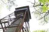
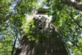
Trundy Point ME | Site 1A
Site 1B
|
Site 1A
Site 1B
|
Site 1A
Site 1B
|
Site 1A
Site 1B
|
Both towers open to public |
  |
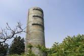
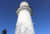
Cape Elizabeth ME | Site 1B
Site 2A
|
Site 1B
Cylindrical tower to simulate silo Site 2A Built atop old lighthouse to simulate water tower |
Site 1B
1943 Site 2A 1874-1942 |
Site 1B
Site 2A
|
Both closed to the public at this time. |
| Prouts Neck ME | ||||||
| Biddeford Pool ME | ||||||
| Cape Porpoise ME | ||||||
| Gelaspus Point ME | ||||||
| Moody Point ME | ||||||
| Bald Head Cliff ME | ||||||
| Cape Neddick ME | ||||||
| Seal Head Point ME | ||||||
| Sisters Point ME | ||||||
| Kittery ME | ||||||
| Appledore Island ME | ||||||
| New Castle NH | ||||||
| New Castle NH | Site 1A
HD OP 1-Upper |
|||||
| Frost Point Rye NH | ||||||
| Rye NH | ||||||
| Rye NH | ||||||
| Hampton NH | ||||||
| Salisbury MA | ||||||
| Plum Island MA | ||||||
| Ipswitch MA | ||||||
| Rockport MA | ||||||
| Rockport MA |
Prouts Neck Tower--Razed 2004--Private Property--Prouts Neck MR
Biddeford Pool Tower--Razed 195?--On a Golf Course--Biddeford Pool MR
Cape Porpoise Tower--Razed 1949 by USACE--Private Property--Cape Porpoise MR
Great Hill/Gelaspus Point--Razed 1949--Private Property--Gelaspus Point MR
Moody Point Station--Partially Razed 1965--Garnsey Brothers Real Estate--Moody Point MR
Bald Head Station--Razed 1964--Bald Head Cliff Hotel--Bald Head Cliff MR
York Cliffs Station--Altered 2001--Private Property--Cape Neddick MR
Seal Head Station--Razed 1979--Private Property--Seal Head Point MR
Sisters Point Tower--Razed 2004--Private Property--Sisters Point MR
Fort Foster Towers (Two)--Double Mine OP & Battery Commanders Tower--Sealed--Fort Foster
Appledore Island Tower--Closed to public--Appledore Island MR
NEW HAMPSHIRE
Fort Constitution Tower--Mine OP--Fenced Off--Fort Constitution
Fort Stark HECP--HDOP 1--Fenced Off--Fort Stark
Fort Dearborn Station--Gun Group 1 Station--Built into 103 BC Station--Open to public--Fort Dearborn
Pulpit Rock Tower--Open occasionally--Pulpit Rock Camp
Rye Ledge Station--Razed 2007-Private Property--Rye Ledge MR
Great Boars Head/Hampton Beach Tower--Private Property--Great Boars Head MR
MASSACHUSETTS
Plum Island Station--Razed 1950s--Closed to public--Plum Island MR
Salisbury Beach Station--Collapsed 1958--Public beach--Salisbury Beach MR
Crane Estate/Castle Hill Station--Razed 1948--Open to public--Castle Hill MR
Halibut Point Tower--Altered 1996 & 2018--Open on weekends--Halibut Point MR
Emerson Point Tower--Private Property--Emerson Point MR
Eastern Point Station--Altered?--Private Property--Eastern Point MR
Coolidge Point Tower--Altered 1974--Private Property--Coolidge Point MR
Smith/Gales Point Station--Altered 1976--Private Property--Gales Point MR
Marblehead Neck Towers (Three)--One 5 story razed 1950s, One Cottage slightly altered & One 5 Story--All Private Property--Marblehead Neck MR
Nahant Towers (Five)--Two 8 story, Two 6 story & One cottage razed 1950s--All Private Property--Fort Ruckman, East Point MR
Deer Island Stations (Amount Undetermined)--All Stations razed 1988-92--No access--Fort Dawes
Lovells Island Stations (Two)--Mine OP & FCS--Open to public--Fort Standish
Great Brewster Island Mine OP (pushed off bluff 197? for safety)--Great Brewster MR
Outer Brewster Island Station--Atop Battery Jewell--Open to public--Outer Brewster Island MR
Georges Island (Two)--Mine OP--Repurposed Endicott tower for Gun Group 5--Open to public--Fort Warren
Point Allerton Stations (Three WWII)--One 7 story FCT--One 4 story FCS (Razed 1978)--One 1 story FCS (Razed 1978)--All Private Property--Point Allerton MR
Strawberry Hill Station--Razed 195? --located in front of 1907 station (now home)--Private Property--Strawberry Hill MR
Minot Stations (Four)--One 8 story FCT--One 5 story steel FCT (Dismantled 194?)--Two 2 story stations altered for residence--Private Property--Strawberry Point MR
Fourth Cliff Stations (Three)--One 5 story FCT--One 3 story FCS--One 1 story station--Private Property--Fourth Cliff MR
Gurnet Point Station--Razed 1998--Open to public--Gurnet Point MR
Elizabeths Islands Stations (Ten)--Five on Cuttyhunk Is., Three on Naushon Is. & Two on Martha's Vineyard (One in surf and one buried)--All open to public--Elizabeth Islands MR
West Island Tower--Sealed--Public Beach--Rocky Point MR
Round Hill Station--Razed 2008--Private Property--Round Hill MR
Gooseberry Neck Towers (Three)--One razed 1978--Sealed--Gooseberry Neck MR
RHODE ISLAND
Warren Point Stations (Two)--One razed 1970 & other razed 2019--Private Property--Warren Point MR
Sauchest Point Stations (Three)--All razed 197?--Open to public--Sauchest Point MR
Beavertail Station--HECP w/ FC Stations--Private Property--Fort Burnside
Conanicut Battery Stations (Six)--All built in 1921 but used thru WWII--All sealed--Public Park--Prospect Hill MR
The Bonnet Station--Mine OP--Private Property--Bonnet Point MR
Camp Varnum Stations (Four)--Slightly altered--Active National Guard Base--Fort Varnum
Point Judith Stations (Five)--Two Stations razed 1979--Two Stations damaged in storms--One tower part of Fishermans Visitors Center--Private Property--Fort Nathanael Greene
Green Hill Stations (Three)--All razed before 1963--Private Property--Green Hill MR
Charleston Station--Altered 2000--Private Property--Quonochontaug Neck MR
Block Island Stations (Eight)--Four towers & Four cottages--Two razed between 1970-85 & Two razed between 1980-85--Private Property--Block Island MR
Noyes Neck Towers (Two)--Razed before 1963--Private Property--Noyes Neck MR
Watch Hill Stations (Two)--One Cottage & One Tower--Razed immediately after WWII--Watch Hill MR
This list is subject to change as more pre-WWII Stations are added