Martha's Vineyard Loc 59A: Difference between revisions
Jump to navigation
Jump to search
J. Malcolm (talk | contribs) m Completed Page |
J. Malcolm (talk | contribs) mNo edit summary |
||
| Line 1: | Line 1: | ||
[[Category:Harbor Defenses of New Bedford/Buzzards Bay]] | [[Category:Harbor Defenses of New Bedford/Buzzards Bay]] | ||
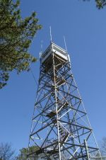
Located on the steel girder Tisbury Fire Tower (not a fire control tower) for watching forest fires. Built in 1930, this tower was | Located on the steel girder Tisbury Fire Tower (not a fire control tower) for watching forest fires. Built in 1930, this tower was 68 feet tall and located on a 65-foot hill in an area called the Great Plains. This tower was used for the Antiaircraft Artillery Intelligence Service (AAIS) OP until 1944 when the tower was dismantled and brought to West Falmouth to replace the Fire Tower at [[West Falmouth Loc 58A|Loc 58A]] in 1946. Loc 58A was also only for the AAIS. | ||
[[File:Loc 59A Fire Tower.jpg|center|frameless|capecodfd.com 2005]] | [[File:Loc 59A Fire Tower.jpg|center|frameless|capecodfd.com 2005]] | ||
Tower Location:41.4167° N, 70.6175° W. | Tower Location:41.4167° N, 70.6175° W. | ||
Latest revision as of 19:11, 14 April 2024
Located on the steel girder Tisbury Fire Tower (not a fire control tower) for watching forest fires. Built in 1930, this tower was 68 feet tall and located on a 65-foot hill in an area called the Great Plains. This tower was used for the Antiaircraft Artillery Intelligence Service (AAIS) OP until 1944 when the tower was dismantled and brought to West Falmouth to replace the Fire Tower at Loc 58A in 1946. Loc 58A was also only for the AAIS.

Tower Location:41.4167° N, 70.6175° W.
SOURCES and REFERENCES
CDSG News November 1989