Cape Elizabeth MR: Difference between revisions
J. Malcolm (talk | contribs) No edit summary |
J. Malcolm (talk | contribs) Quick overhaul on page. |
||
| Line 1: | Line 1: | ||
Loc. 158 Cape Elizabeth was a WWII gun battery, fire control and radar site in Cape Elizabeth ME. | Loc. 158 Cape Elizabeth was a WWII gun battery, fire control and radar site in Cape Elizabeth ME. | ||
[[Category:Harbor Defenses of Portland]] | [[Category:Harbor Defenses of Portland]] | ||
[[File:Cape Elizabeth MR Plan.jpg|thumb|311x311px| | [[File:Cape Elizabeth MR Plan.jpg|thumb|311x311px|Layout 1945.]] | ||
The Cape Elizabeth Military Reservation was established in 1942 for the [[:Category:Harbor Defenses of Portland|Harbor Defenses of Portland]]. Batteries 101 and 201 were to be built along with Fire Control and Radar Stations. The reservation was split into three parcels. Site 1A was 32.62 acres acquired in 1943 for Battery 201. Site 1B was directly behind site 1A and was 7.3 acres acquired in 1943 for a combined Fire Control Tower and Battery Commanders Station. Site 2A was .30 acres acquired in 1942 for a combined Fire Control and Radar Tower on the former lighthouse reservation. Site 3A was also acquired in 1942 for a radar tower at Dyer Point. This was a sub post of [[Fort Williams]] nearby. Men stationed here were mostly billeted from [[Fort Williams]] but the post could support a garrison of 102 men. The Army used existing residences as barracks and officers quarters. A 100 foot long barracks was built adjacent to the Battery Commanders station at Site 1B. | The Cape Elizabeth Military Reservation was established in 1942 for the [[:Category:Harbor Defenses of Portland|Harbor Defenses of Portland]]. Batteries 101 and 201 were to be built along with Fire Control and Radar Stations. The reservation was split into three parcels. Site 1A was 32.62 acres acquired in 1943 for Battery 201. Site 1B was directly behind site 1A and was 7.3 acres acquired in 1943 for a combined Fire Control Tower and Battery Commanders Station. Site 2A was .30 acres acquired in 1942 for a combined Fire Control and Radar Tower on the former lighthouse reservation. Site 3A was also acquired in 1942 for a radar tower at Dyer Point. This was a sub post of [[Fort Williams]] nearby. Men stationed here were mostly billeted from [[Fort Williams]] but the post could support a garrison of 102 men. The Army used two existing residences as barracks and officers' quarters. A 100-foot-long barracks was built adjacent to the Battery Commanders station at Site 1B, and two other buildings were constructed next to Battery 201. | ||
== Fire Control and Radar Towers == | == Fire Control and Radar Towers == | ||
| Line 9: | Line 9: | ||
=== Site 1B The Silo === | === Site 1B The Silo === | ||
[[File:Cape Elizabeth MR 16.jpg|left|thumb|195x195px|The Silo in 2023]] | [[File:Cape Elizabeth MR 16.jpg|left|thumb|195x195px|The Silo in 2023]] | ||
This Fire Control Tower was built in | This Fire Control Tower was built in 1942 as a Battery Commanders Station for Battery 201. It also housed a Base-End Station for Battery 201 (It would have housed the Gun-Group post, but it was never established after Battery 101's termination in 1942. The tower was built next to a farmhouse and disguised as a silo. Plans from 1941 show was to have been a three-story cottage style Fire Control station. The adjacent farmhouse was occupied by its owner, and the barn was used as a recreation building. In 1945 the barn burned and the house was subsequently destroyed. This tower was nearly identical to the one at [[Emerson Point MR]]. Today the tower is sealed and is slowly deteriorating. Barracks were once located next to the tower. | ||
=== Site 2A The Lighthouse === | === Site 2A The Lighthouse === | ||
The West Lighthouse (1874) at Cape Elizabeth has been used for Fire Control since 1925 for Battery Kearny-Chase at [[Fort Preble]]. In 1935-6 plans were made for an octagonal wooden station to replace the earlier one. This design was later revised to be a square wooden two-level station with an AAIS OP on the roof. The current combined fire control and radar tower was built in 1942 of reinforced concrete on the site of the earlier station. This station was not disguised as a lighthouse but rather a water tower. A faux wooden tank held | The West Lighthouse (1874) at Cape Elizabeth has been used for Fire Control since 1925 for Battery Kearny-Chase at [[Fort Preble]]. In 1935-6 plans were made for an octagonal wooden station to replace the earlier one. This design was later revised to be a square wooden two-level station with an AAIS OP on the roof. The current combined fire control and radar tower was built in 1942 of reinforced concrete on the site of the earlier station. This station was not disguised as a lighthouse but rather a water tower. A faux wooden tank held a SCR-296 radar for Battery 201. This station was for Battery 202 at [[Jewell Island MR]] and Battery 203 at [[Peaks Island MR]]. During the war the tower was painted reddish brown. The radar was removed around 1946. The tower was sold and the DPF pads were drilled out at one point, eventually the faux water tank disappeared as well. Gary Merrill who was the ex-husband of Bette Davis owned the tower from 1971-83. In 1985 the tower was purchased by Ken Lane who restored the exterior of the tower and has lived in the adjacent house since. <center><gallery mode="nolines" heights="90"> | ||
File: | File:L158 2A FC Lighthouse.jpg|View from Beacon Ln. | ||
File:Cape Elizabeth MR (2) 18.jpg|Range data on the top level | File:Cape Elizabeth MR (2) 18.jpg|Range data on the top level. | ||
File:Cape Elizabeth MR (2) 28.jpg|Spiral stairs in the lighthouse. | |||
File:Cape Elizabeth MR (2) 28.jpg| | File:1983WestLight.jpg|The tower before restoration in 1983. | ||
File:1983WestLight.jpg|The tower before restoration | |||
</gallery></center> | </gallery></center> | ||
=== Site 3A The Radar Tower === | === Site 3A The Radar Tower === | ||
In 1942 a steel radar tower with a faux wooden tank was built at Dyer Point next to the Lobster Shack. A corrugated steel operations building, and two generator buildings accompanied this tower. This radar was to serve Battery Foote at [[Fort Levett]]. It could detect enemy ships and the crew in the operations building would report the ships' location to Battery Foote's plotting room. This tower was scrapped in 1948. The operations building and generator buildings survived into the 1950s.<center | [[File:L158 3A SCR 296 footings 8-19-24.jpg|left|thumb|SCR 296 Footers 2024.]] | ||
[[File:SCR296.jpg|thumb|261x261px|1946 image.]] | |||
In 1942 a steel radar tower with a faux wooden tank was built at Dyer Point next to the Lobster Shack. A corrugated steel operations building, and two generator buildings accompanied this tower. This radar was to serve Battery Foote at [[Fort Levett]]. It could detect enemy ships and the crew in the operations building would report the ships' location to Battery Foote's plotting room. This tower was scrapped in 1948. The operations building and generator buildings survived into the 1950s.<center></center> | |||
| Line 37: | Line 35: | ||
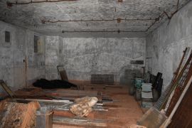
== Battery 201 == | == Battery 201 == | ||
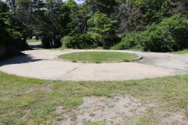
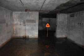
Construction began on Battery 201 in | Construction began on Battery 201 in 1943, and it was completed in 1944 unarmed. This battery was to have two 6-inch shielded guns on barbette carriages. This battery was designated Battery #1 on defense charts and was proposed to be named Battery Fesseden. Fire Control Stations for this battery were located at [[Fletchers Neck MR]], [[Prouts Neck MR]], [[Cape Elizabeth MR]], [[Fort Levett]] and [[Jewell Island MR]]. The battery would have had a range of 15 miles and 5 rounds of shells weighing 105 pounds could be shot per minute. In 1946 the battery was abandoned by the coast artillery. <center><gallery mode="packed-overlay"> | ||
File: | File:158 201 emp1 entrance 5-23-26.jpg|Emplacement 1 | ||
File:Cape Elizabeth MR 10.jpg|Emplacement 1 | |||
File:Cape Elizabeth MR 05.jpg|Emplacement 2 | |||
File:Cape Elizabeth MR 10.jpg|Emplacement | File:Cape Elizabeth MR 06.jpg|Emplacement 2 | ||
File:Cape Elizabeth MR 05.jpg|Emplacement | File:Cape Elizabeth MR 11.jpg|Air vent | ||
File:Cape Elizabeth MR 06.jpg|Emplacement | File:Cape Elizabeth MR 12.jpg|Center entrance | ||
File:Cape Elizabeth MR 11.jpg| | File:Cape Elizabeth MR (2) 07.jpg|Breaker box | ||
File:Cape Elizabeth MR | File:158 201 plotting room facing swb 5-23-26.jpg|Plotting Room | ||
File:Cape Elizabeth MR (2) | File:158 201 generator room 5-23-26 (2).jpg|Generator room | ||
File: | |||
File: | |||
</gallery></center> | </gallery></center> | ||
[[File:158 201 emp1 azimuth scope 5-23-26.jpg|thumb|237x237px|Azimuth scope set up during public tours.]] | |||
== Present == | == Present == | ||
In 1955 sites 1A and 1B were purchased by the state to create [https://apps.web.maine.gov/cgi-bin/online/doc/parksearch/details.pl?park_id=28 Two Lights State Park] which opened in 1961. In 1995 an interpretation project was set up inside the battery which involved putting new electric lights and exit signs in. Interpretive plaques still remain marking each of the rooms with their purpose. As of 2026 the battery is open for monthly public tours. Future plans include opening the Battery Commanders tower was well. Today all of the reservation except for the West Light is accessible to the public. A fee is charged at the park. | |||
In 1955 sites 1A and 1B were | |||
=== SOURCES and REFERENCES: === | === SOURCES and REFERENCES: === | ||
Latest revision as of 11:27, 20 June 2026
Loc. 158 Cape Elizabeth was a WWII gun battery, fire control and radar site in Cape Elizabeth ME.

The Cape Elizabeth Military Reservation was established in 1942 for the Harbor Defenses of Portland. Batteries 101 and 201 were to be built along with Fire Control and Radar Stations. The reservation was split into three parcels. Site 1A was 32.62 acres acquired in 1943 for Battery 201. Site 1B was directly behind site 1A and was 7.3 acres acquired in 1943 for a combined Fire Control Tower and Battery Commanders Station. Site 2A was .30 acres acquired in 1942 for a combined Fire Control and Radar Tower on the former lighthouse reservation. Site 3A was also acquired in 1942 for a radar tower at Dyer Point. This was a sub post of Fort Williams nearby. Men stationed here were mostly billeted from Fort Williams but the post could support a garrison of 102 men. The Army used two existing residences as barracks and officers' quarters. A 100-foot-long barracks was built adjacent to the Battery Commanders station at Site 1B, and two other buildings were constructed next to Battery 201.
Fire Control and Radar Towers
Two Fire Control Towers and two radar stations were built on the reservation. A fire control switchboard was located in Battery 201. Plans from 1941 indicate a Fire Control tower with two observing floors (serving Battery Steele and Battery 101) was to be located at 20 beacon lane but no such tower was ever built.
Site 1B The Silo

This Fire Control Tower was built in 1942 as a Battery Commanders Station for Battery 201. It also housed a Base-End Station for Battery 201 (It would have housed the Gun-Group post, but it was never established after Battery 101's termination in 1942. The tower was built next to a farmhouse and disguised as a silo. Plans from 1941 show was to have been a three-story cottage style Fire Control station. The adjacent farmhouse was occupied by its owner, and the barn was used as a recreation building. In 1945 the barn burned and the house was subsequently destroyed. This tower was nearly identical to the one at Emerson Point MR. Today the tower is sealed and is slowly deteriorating. Barracks were once located next to the tower.
Site 2A The Lighthouse
The West Lighthouse (1874) at Cape Elizabeth has been used for Fire Control since 1925 for Battery Kearny-Chase at Fort Preble. In 1935-6 plans were made for an octagonal wooden station to replace the earlier one. This design was later revised to be a square wooden two-level station with an AAIS OP on the roof. The current combined fire control and radar tower was built in 1942 of reinforced concrete on the site of the earlier station. This station was not disguised as a lighthouse but rather a water tower. A faux wooden tank held a SCR-296 radar for Battery 201. This station was for Battery 202 at Jewell Island MR and Battery 203 at Peaks Island MR. During the war the tower was painted reddish brown. The radar was removed around 1946. The tower was sold and the DPF pads were drilled out at one point, eventually the faux water tank disappeared as well. Gary Merrill who was the ex-husband of Bette Davis owned the tower from 1971-83. In 1985 the tower was purchased by Ken Lane who restored the exterior of the tower and has lived in the adjacent house since.
-
 View from Beacon Ln.
 -
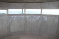 Range data on the top level.
 -
 Spiral stairs in the lighthouse.
 -
 The tower before restoration in 1983.

_18.jpg)
_28.jpg)

Site 3A The Radar Tower


In 1942 a steel radar tower with a faux wooden tank was built at Dyer Point next to the Lobster Shack. A corrugated steel operations building, and two generator buildings accompanied this tower. This radar was to serve Battery Foote at Fort Levett. It could detect enemy ships and the crew in the operations building would report the ships' location to Battery Foote's plotting room. This tower was scrapped in 1948. The operations building and generator buildings survived into the 1950s.
Battery 101

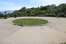
Battery 101 was going to be a twin 16-inch Long Range Barbette Battery but was terminated. This battery would have been identical to Battery Steele at Peaks Island MR. Battery 101 would have been located on top of Mares Hollow Lane north of Battery 201.
Battery 201
Construction began on Battery 201 in 1943, and it was completed in 1944 unarmed. This battery was to have two 6-inch shielded guns on barbette carriages. This battery was designated Battery #1 on defense charts and was proposed to be named Battery Fesseden. Fire Control Stations for this battery were located at Fletchers Neck MR, Prouts Neck MR, Cape Elizabeth MR, Fort Levett and Jewell Island MR. The battery would have had a range of 15 miles and 5 rounds of shells weighing 105 pounds could be shot per minute. In 1946 the battery was abandoned by the coast artillery.
-
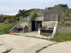 Emplacement 1
 -
 Emplacement 1
 -
 Emplacement 2
 -
 Emplacement 2
 -
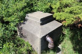 Air vent
 -
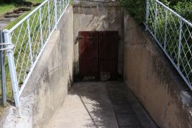 Center entrance
 -
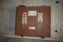 Breaker box
 -
 Plotting Room
 -
 Generator room


_07.jpg)

.jpg)

Present
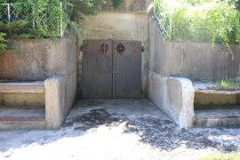
In 1955 sites 1A and 1B were purchased by the state to create Two Lights State Park which opened in 1961. In 1995 an interpretation project was set up inside the battery which involved putting new electric lights and exit signs in. Interpretive plaques still remain marking each of the rooms with their purpose. As of 2026 the battery is open for monthly public tours. Future plans include opening the Battery Commanders tower was well. Today all of the reservation except for the West Light is accessible to the public. A fee is charged at the park.