Naushon Island MR: Difference between revisions
J. Malcolm (talk | contribs) Completed Page |
J. Malcolm (talk | contribs) added brief info |
||
| (3 intermediate revisions by the same user not shown) | |||
| Line 1: | Line 1: | ||
[[Category:Harbor Defenses of New Bedford/Buzzards Bay]] | [[Category:Harbor Defenses of New Bedford/Buzzards Bay]] | ||
Loc. 58 Naushon Island was a WWII Fire Control Site in Gonsold MA. | |||
=== Site 1 - South Bluff === | === Site 1 - South Bluff === | ||
This FC Station was completed in 1943 and was the 7th spotting station and base-end station for Battery Milliken at [[Fort Rodman]] in New Bedford. The entry hatch to this station also served as Antiaircraft Artillery Intelligence Service (AAIS) OP 6. A portable 60-inch searchlight (#5) was located near the two-story barracks building that served for this site. The hurricane of September 14th, 1944, may be the reason the barracks are gone but they also may have been salvaged post-war.<gallery mode="packed | This FC Station was completed in 1943 and was the 7th spotting station and base-end station for Battery Milliken at [[Fort Rodman]] in New Bedford. The entry hatch to this station also served as Antiaircraft Artillery Intelligence Service (AAIS) OP 6. A portable 60-inch searchlight (#5) was located near the two-story barracks building that served for this site. The hurricane of September 14th, 1944, may be the reason the barracks are gone but they also may have been salvaged post-war.<gallery mode="packed" heights="50"> | ||
File:BeachFCS.jpg|2017 Imagery showing FC and Barracks | File:BeachFCS.jpg|2017 Imagery showing FC and Barracks | ||
File:Naushon Island Site Map.jpg|Site Map | File:Naushon Island Site Map.jpg|Site Map | ||
| Line 9: | Line 9: | ||
=== Site 2 - Eagle Hollow === | === Site 2 - Eagle Hollow === | ||
Two FC Stations were built in an area called Eagle Hollow in 1943. Site 2B which is the topmost station in the aerial image, served as the 6th spotting station and base-end station for Battery Milliken. The bottom-most station in the image served as the 5th spotting station and base-end station for Battery 210 at [[Mishuam Point MR]]. This site had two portable 60-inch searchlights (#6 & #7). A two-story barracks building was built near the stations along with another building I am yet to identify (Either latrines or searchlight powerhouse). Similarly to Site 1, the barracks were either removed post-war or destroyed in the September 14th hurricane. Although, based on the fact the unidentified building near the barracks was still standing in 2010, the barracks were probably salvaged post-war (1946-48). A cable terminal may remain on the beach for telephone lines back to mainland.<gallery mode="packed | Two FC Stations were built in an area called Eagle Hollow in 1943. Site 2B which is the topmost station in the aerial image, served as the 6th spotting station and base-end station for Battery Milliken. The bottom-most station in the image served as the 5th spotting station and base-end station for Battery 210 at [[Mishuam Point MR]]. This site had two portable 60-inch searchlights (#6 & #7). A two-story barracks building was built near the stations along with another building I am yet to identify (Either latrines or searchlight powerhouse). A house(?) which may have served as officers' quarters existed during the army's tenure here and was demolished in 2008. Similarly to Site 1, the barracks were either removed post-war or destroyed in the September 14th hurricane. Although, based on the fact the unidentified building near the barracks was still standing in 2010, the barracks were probably salvaged post-war (1946-48). A cable terminal may remain on the beach for telephone lines back to mainland.<gallery mode="packed"> | ||
File:MtsuratFCS.jpg|FC Stations 2017 | File:MtsuratFCS.jpg|FC Stations 2017 | ||
File:Suratbarracks.jpg|Barracks and latrine? 2017 | File:Suratbarracks.jpg|Barracks and latrine? 2017 | ||
Latest revision as of 08:09, 23 March 2026
Loc. 58 Naushon Island was a WWII Fire Control Site in Gonsold MA.
Site 1 - South Bluff
This FC Station was completed in 1943 and was the 7th spotting station and base-end station for Battery Milliken at Fort Rodman in New Bedford. The entry hatch to this station also served as Antiaircraft Artillery Intelligence Service (AAIS) OP 6. A portable 60-inch searchlight (#5) was located near the two-story barracks building that served for this site. The hurricane of September 14th, 1944, may be the reason the barracks are gone but they also may have been salvaged post-war.
-
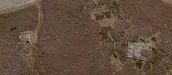 2017 Imagery showing FC and Barracks
 -
 Site Map

Site 2 - Eagle Hollow
Two FC Stations were built in an area called Eagle Hollow in 1943. Site 2B which is the topmost station in the aerial image, served as the 6th spotting station and base-end station for Battery Milliken. The bottom-most station in the image served as the 5th spotting station and base-end station for Battery 210 at Mishuam Point MR. This site had two portable 60-inch searchlights (#6 & #7). A two-story barracks building was built near the stations along with another building I am yet to identify (Either latrines or searchlight powerhouse). A house(?) which may have served as officers' quarters existed during the army's tenure here and was demolished in 2008. Similarly to Site 1, the barracks were either removed post-war or destroyed in the September 14th hurricane. Although, based on the fact the unidentified building near the barracks was still standing in 2010, the barracks were probably salvaged post-war (1946-48). A cable terminal may remain on the beach for telephone lines back to mainland.
-
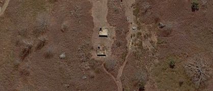 FC Stations 2017
 -
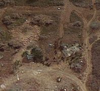 Barracks and latrine? 2017
 -
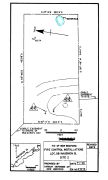 Site Map


SOURCES and REFERENCES
November 1989 edition of the CDSG News