Gurnet Point MR: Difference between revisions
J. Malcolm (talk | contribs) mNo edit summary |
J. Malcolm (talk | contribs) m Updated minor details |
||
| (2 intermediate revisions by the same user not shown) | |||
| Line 1: | Line 1: | ||
Built in 1943 on the ramparts of Fort Andrews (1776), this | Loc. 111 Gurnet Point was a WWII Fire Control site on Gurnet Point in Plymouth MA.[[File:Gurnet Point Fire Control Station 03.jpg|left|thumb|253x253px|The station in the mid 90s]] | ||
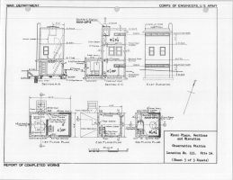
[[File:Gurnet Point Elevation Drawings.jpg|thumb|259x259px|1944 RCW Elevation Drawings]] | |||
Built in 1943 for $9,731 on the ramparts of Fort Andrews (1776), this station was the most southern in the [[:Category:Harbor Defenses of Boston|HD of Boston]]. It was located on a 4.5-acre plot owned by the Coast Guard. The station is a strange design with two observation levels separated by a floor with large rectangular windows (Used by USCG for observation). The upper observation level served [[Fourth Cliff MR|Battery 208]] with a Depression Position Finder and the lower level was the Groupement 1 OP with an Azimuth Instrument. The rear section of the structure consisted of the entrance and a generator room. A Pilgrim Atomic power plant siren was installed on the station in 1980. The station was demolished in November 1998 due to its poor condition. Today there are no remains and most of the rampart the tower was located on has eroded away. | |||
[[Category:Harbor Defenses of Boston]] | [[Category:Harbor Defenses of Boston]] | ||
=== SOURCES and REFERENCES: === | |||
[https://mhc-macris.net/ Massachusetts Cultural Resource Information System] | |||
[https://plymouthantiquarian.org/ Plymouth Antiquarian Society] | |||
Plymouth | |||
[https://cdsg.org CDSG] | |||
[https://northamericanforts.com North American Forts Network] | [https://northamericanforts.com North American Forts Network] | ||
[https://lighthousefriends.com Lighthouse Friends] | [https://lighthousefriends.com Lighthouse Friends] | ||
Latest revision as of 20:48, 7 December 2024
Loc. 111 Gurnet Point was a WWII Fire Control site on Gurnet Point in Plymouth MA.


Built in 1943 for $9,731 on the ramparts of Fort Andrews (1776), this station was the most southern in the HD of Boston. It was located on a 4.5-acre plot owned by the Coast Guard. The station is a strange design with two observation levels separated by a floor with large rectangular windows (Used by USCG for observation). The upper observation level served Battery 208 with a Depression Position Finder and the lower level was the Groupement 1 OP with an Azimuth Instrument. The rear section of the structure consisted of the entrance and a generator room. A Pilgrim Atomic power plant siren was installed on the station in 1980. The station was demolished in November 1998 due to its poor condition. Today there are no remains and most of the rampart the tower was located on has eroded away.